Total Pageviews

Saturday, July 30, 2011

The Mingo and Tuscarora Indians

I still don’t quite understand who really owns the land on Mt. Zion Road, the ancestral home of many of my relatives.  Is it the Mingo Tribal Preservation Trust or the Tuscarora Ranch, LLC?  Nevertheless, I became quite interested in the Mingo and Tuscarora Indians and their connection with Wilkes County, North Carolina.  Therefore, I resorted to the Internet and hard-copy references for information.  And this is what I learned…
I found that understanding the difference between the Mingo Indians and the Tuscarora Indians is  complicated.  As in much literature, different authors tend to have different interpretations of concepts and events.  Therefore, my comments represent my assimilations and interpretations of what I have read from various sources. 
The Mingo Indians were a small group of Native Americans who were related to the Iroquois Indians.  By 1750 they had moved into Ohio and today are often referred to as the Ohio Seneca Indians.  I haven’t found any reference to the Mingo Indians in North Carolina.
The Tuscarora Indians, an agricultural tribe that was also related to the Iroquois, inhabited the coastal plans of North Carolina along the Neuse River.  As with most of the Native Americans, they were very much opposed to the western expansion of the white settlers.  The Tuscarora Indians also developed a very lucrative trade serving as the middlemen in trading rum and other goods with the Indians in the Piedmont region.  As a consequence of encroachment by the settlers into their land and mistreatment by the white settlers, a war between the Tuscarora Indians and the settlers erupted in September 1711 and continued through March of 1713 at which time the Indians were defeated.  By 1722 many of the Tuscarora Indians returned New York to live with their northern relatives, the Iroquois.  Again, I found no documentation of Tuscarora Indians in Wilkes County, North Carolina.  Wilkes was inhabited by the Cherokee Indians during those early years.
The connection between the Mingo Indians and the Tuscarora Indians appears to be their blood relationship to the Iroquois Indians.
If any of my followers have additional information regarding these two groups, please comment.  As always, I encourage your comments, suggestions, corrections, and information.

Wednesday, July 27, 2011

The Cemetery

In my last post I described the land at Stony Fork.  In this one I would like to go a step further in the description by telling about the family cemetery plot that is located there.
During my first visit to Stony Fork with my cousins, one cousin (CALT) told about her mother, Flora West Lowe, visiting the homeland sometime prior to her death in 1993.  According to the story, Flora took her cousin, Edna Triplett Coder, with her, and the two of them cleaned up the family plot and put a split rail fence around it. The farmhouse where Thomas Harvey and America Ann McNeil West had lived was still standing on the site across and down the road from the cemetery on Mt. Zion Road just before Stony Fork Road branches to the right off Mt. Zion Road.  Land records indicate that the Wests owned land on both sides of Stony Creek.  An assumption can be made that their land must have been on both sides of Mt. Zion Road, also.
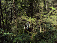
In our efforts to locate the land, we talked with several individuals in the area, one of whom identified the family plot and said that the owners kept a path mowed up to it.  The plot is located adjacent to a barn and corral on a knoll in a well-maintained field or pasture.   We drove to the location and walked up the knoll to the plot.  We found the fence rotting and falling down and the ground within the fence covered with thick, high grass which was taller than our heads.  Even though CALT ventured into the thicket of grass, she didn’t stay very long and said that she saw no evidence of any grave markers.  I, being afraid of poison ivy and snakes, didn’t risk going in.  Out of respect and desire to preserve the cemetery, both of us felt that we would like to clean it up.
The farmer who helped us identify the land and cemetery said that it was owned by a Jesse Horton and that “he planned to do something with it.”  We didn’t know exactly what this meant.  Did he mean the development of a subdivision or some other type of development? 
For almost a year, I have been trying to find out who owned the land on which this family cemetery is located and to get in touch with this owner.  Even though I searched the White Pages and Yellow Pages on the Internet, called directory assistance for phone numbers, made phone calls, and wrote a letter, I was unable to find the owner.  In February 2011, I received a phone call from the one who received my letter.  He had been the mail carrier on the Stony Fork/Mt. Zion mail route and had known the Wellborn family very well.  He described the nickname that Mr. Wellborn had given him.  Of course, these Wellborn heirs would have been a much later generation of Wellborns than those who originally took ownership of the farm.  He was extremely helpful in confirming that we had found the location of the farm and that we had identified the site where the farmhouse had been.   He described the farmhouse, which burned sometime after 1993, as being a very nice, well-kept, two-story white house.  He thought the present owner, Mr. Jesse Horton, who had lived for some time in a double-wide home on the site of the farmhouse, lived in Wilkesboro.  I still didn’t know how to reach him!  
Oh my!  I have gotten sidetracked again, but some additional knowledge about the farm is important to understanding the context of the cemetery.  And now, back to the cemetery!
Of course, we assumed that this cemetery plot was the West Family Plot about which CALT had learned from her mother.  Recently, with the help of a 4th cousin whom I have met on the Internet (JJL) and Wilkes County cemetery research completed by a 5th cousin 1x removed (GFM),  I have learned that this cemetery is the Thomas Land Family Cemetery.   William Thomas and Nancy Jane Carlton Land (my 3rd great grandparents) were the parents of Nancy Land West who was the wife of Alexander Balus West and mother of Thomas Harvey West.   Many thanks go to JJL and GFM for your help in solving this piece of the puzzle.
As I have researched land documents and, more recently, minutes of church proceedings, I have found that the Wests, Swansons, Witherspoons, Lands, Carltons, McNeils, Fergusons, and Barlows, apparently all lived within close proximity to each other, often owning adjacent properties.  As a widow, Nancy Land West bought land from her parents which, of course, went to her only child, Thomas Harvey West. 
Likewise, Thomas Harvey’s father, Alexander Balus West, had purchased some of his father’s land (John Balus West).  Moreover, Franklin West had purchased some land from his father, John Balus West.  Other children of John Balus West may have purchased land from him, also.  I just haven’t delved that deeply into the records of Alexander Balus West’s siblings.  Therefore, determining who originally owned which parcels of land is extremely difficult. 
In retrospect, remember that the parcels of land in this area that belonged to Alexander Balus West/Nancy Land West and their only child, Thomas Harvey West/America Ann McNeil, were traded by Thomas Harvey West for the land in Banner Elk, North Carolina, owned by the G. W. Wellborn family, about 1902.
Furthermore, one may easily see why recent generations thought that the cemetery was the West family plot.  In fact, two “known” West children, A. J. West and Willard A. West who were the young children of Thomas Harvey and Nancy Land West, are buried in the Thomas Land Family Cemetery. 
According to the Wilkes County Cemetery Database[i] maintained by GFM and JDM, the plot is 75’X50’ with 8 marked graves and approximately 10 unmarked graves.   At the time of the verification of the cemetery and graves in 1989, identifiable graves were those of the following:  Jane Carlton Land, T. C. “Tommy” Land, Thomas Land, Jim Pennell, Robinett Infant, Molly Land Robinett, A. J. West, and Willard A. West.  Some of these tombstones were turned over and/or broken.
During my last visit to Wilkesboro, North Carolina on June 16 and 17, 2011, I was able to determine the present owners of the property on which this cemetery is located.  Currently, nearly 5,000 acres of land in the Stony Fork/Mt. Zion community, which likely includes all of the land formerly owned many years ago by the Wests, Swansons, Witherspoons, Lands, Carltons, McNeils, Fergusons, and Barlows, are currently owned by the Tuscarora Ranch, LLC, the grantee, with the grantors being the trustees of the Mingo Tribal Preservation Trust.  The trustees are listed as Jesse W. Horton, Jr., Mark R. Ricks, and George R. Wilson. 
I have written the Tuscarora Ranch asking permission to repair the fence around the plot and possibly cut back some of the tall grass that covers it.  Also, I have asked permission to make periodic visits to the cemetery and to do some minimal maintenance.   Cutting back the grass and repairing the fence, along with occasional visits, would indicate that the cemetery has not been forgotten and abandoned.  If we are granted this permission, I hope to find some “cousins” who would be willing to help!
Regarding the tall grass – I have recently learned from cousin GFM that the tall grass found on the plot was planted by the owners as, I presume, a means of protection.  Cutting the grass only makes it come back thicker.  Digging it up would only disturb the graves.  Therefore, the best thing to do at the end of winter weather before new growth begins would be to cut it back enough in order to reveal the markers and provide the appearance of being maintained.
Note:  In legal documents, the name Wellborn is spelled several different ways (Welborn, Wellborn, Wellborne,  Welborne, and Wellbourne).  I am using the spelling found in a family historical article written by Homer C. Wellborn, G. W. Wellborn’s son.


[i] McNeil, George F. and Joyce D. McNeil. “Wilkes County Database.” Wilkesboro, NC, 2009.

Monday, July 25, 2011

Stony Fork


No matter which migration route that Alexander West I took, he eventually made it to the land that later became part of Wilkes County.  Before coming to that area which eventually became Wilkes, Alexander West I is documented (1752-1755) in tax and census records in Orange County where, at least, two of his children, Alexander II and John, were born.  At that time in North Carolina’s history, a section of North Carolina that is today known as Hillsborough in Orange County became the economic and political center of the backcountry.[i] After living in Orange County for an unknown period of time, early records of 1775 document Alexander West I as being in Surry County, from which Wilkes was created in 1777.  By 1778, he had arrived in Wilkes County as noted by his documented presence at Glady Branch.

After I began researching the West family and reading about Stony Fork and the other areas of family significance, locations such as Glady Branch, Glady Fork, Redy Branch, Lewis Fork, Mason’s Branch, Bull Branch, and Naked Creek, I wanted to visit the Stony Fork area of Wilkes County.  In September 2010, two of my 1st cousins 1x removed and a 2nd cousin along with two of our spouses made a day-trip to the valley where Stony Creek winds among the idyllic pastures.  Stony Fork Creek runs off the slopes of Tompkins Knob and the Blue Ridge Parkway and quietly makes its way between Dividing Ridge and Elk Ridge and then to the Yadkin River above the Kerr Scott Reservoir.  As we explored the area, we were fortunate to discover a large and beautiful waterfall, which almost seemed untouched by human hands.  The waterfall was located on the north western end of Stony Fork Road.  The waterfall, which drops, according to the Internet, over 200 feet, feeds into Stony Creek and ultimately into the Yadkin River.  Since I was on the road above and was too far way, the photograph that I took doesn't do justice to this awesome sight.

The former West property lies in this beautiful bottom-land, nestled between   these two forested ridges.  At the time of our visit, we were not positive that we had located the site where the house had been.  This past winter, however, I spoke with a mail carrier who had delivered the mail to the Welborn family, the owners at that time; he had known them very well.  Certainly, those Welborn family heirs were from a more recent generation.   After I described the site, he confirmed that we had, indeed, found the location where the house had been.  The house had burned a number of years ago, but one of the cousins on the trip said that her mother had been there in the 1980s and saw the house before it burned.
Not only is the land picturesque, serene, and pastoral but is noticeably quiet without the noise of vehicular traffic on its winding roads.   The mountain ridges on either side of the flat bottom-land provide a presence of security and comfort from the outside world.   But, the land is also quite remote.  After leaving Highway 421, we wound down and around country roads for some distance before we reached the Stony Fork area.  I can just imagine that once winter weather “set in” the local residents were held captive by the distance and the terrain for the duration.  Surely, they must have been extremely independent and self-sufficient to have survived.  In spite of the hardships that they endured, they were certainly in a setting that could be called “God’s country.”
Thanks to my cousins (FL, CALT, NLS, and AML) for taking my husband and me to Stony Fork.  Not only was the weather perfect, but we also enjoyed a great time.
Note:  Stony Fork is spelled two ways (Stoney Fork and Stony Fork) in legal documents and on old maps.  Also, the spellings for Glady Branch, Glady Fork, and Redy Branch are those used in the legal documents and maps of that period.

[i] Mobley, Joe. A. (ed.). The Way We Lived in North Carolina. Chapel Hill: University of North Carolina Press, 2004.

Friday, July 22, 2011

What Did Alexander West I Find When He Came to Wilkes County?

He found Indians and danger!

Tradition indicates that many hard-fought battles occurred between the white settlers and the Indians among the swamps along the Yadkin River.  The Cherokee Indians were quite numerous and had their capital village at what is known today as North Wilkesboro.  They had numerous wigwams along the banks of the Yadkin and Reddies Rivers.
He found an unpopulated back country!
Supposedly, by 1727, no white men had been in what is now Wilkes County.  In 1746 Governor Rowan wrote that “in the year of 1746, I was in the territory from the Saxaphaw [Haw River] to the mountains, and there was not above one hundred fighting men in all that back country.”   By 1749 according to the tax polls, about 300 taxable men lived west of North Carolina’s Haw River.  By 1750, many settlers, most of whom were English, began coming to western North Carolina.  As mentioned in a previous blog post, “Migration Routes and Their Effects on Settlements,” settlers came for various reasons—religious, political, and economic.  Politically, they came for a desire for greater freedom than they had under British rule in other parts of the colony.  Living in such a remote section as western North Carolina provided them with greater autonomy.
He found a source of plenty!
By 1750, the North Carolina “back county” was becoming more populated.  As they entered this western North Carolina land, settlers found that many bottom lands had already been cleared by the Indians.  In the upper Yadkin River Valley, they found land teaming with bear, deer, and other animals.  Supposedly, a hunter could obtain two or three thousand pounds of bear grease in a season.  Daniel Boone purportedly killed 99 bears along the waters of Bear Creek.  A hunter could kill four or five deer a day.
He found an abundance land available through land grants and purchases!
By 1752 Lord Granville, who did not sell his land back to the King of England as some of the English proprietors had done, provided land grants for 8,773 acres of land lying within the present borders of Wilkes County.
Sources:
Barclay, Carolyn R. “Just Who Were the Scots-Irish,” Genealogical.com, Aug. 14, 2010
Crouch, John. Historical Sketches of Wilkes County, 1902

Tuesday, July 19, 2011

Migration Routes and Their Effects on Settlements


Most genealogists stress the importance of studying the migration routes of those who settled in specific areas.  Until recently, I haven’t given much thought to doing that.  However, after reviewing a video presentation, Migration Routes and Settlement Patterns, 1607-1890, by Dr. George F. Schweitzer, Ph.D., ScD, copyright 1998, I have become more interested in these migration patterns and how they may have influenced my ancestors who moved into the high country of North Carolina.  Not only do I have West ancestors including the Lands/Carltons, McNeils/Barlows, Swansons, and Witherspoons from those high country counties of Wilkes and Avery, but also the Hugheses/Hoilmans and Honeycutts/Canipes from the high country counties of Yancey and Mitchell, all of whom may have followed those routes as they sought, for one reason or another, new land.  Wow!  What a daunting challenge I have if, and when, I am able to research these families!

Appalachian Mountains

Before continuing with the migration routes and their effects on settlements, a basic explanation of the Appalachian Mountains, is needed.  Using Internet sources, I have researched the Appalachian Mountains, the Allegheny Mountains, the Blue Ridge Mountains, and the Cumberland Mountains and have discovered that different writers provide facts and names that somewhat differ.  Therefore, sorting out, synthesizing, and organizing the information in my mind has been somewhat difficult.  In view of the fact that I am still learning about the geography of the land, the migration routes, and the settlement patterns, I must provide a disclaimer that I may have some inaccuracies or misinterpretations.  Please let me know if you notice any in my analyses.

The Appalachian Mountains, representing a very old and vast system of mountains in the eastern section of North America, are found in this country in 18 of our states.  The Allegheny Mountain range is on the western side, the Blue Ridge Mountain range on the eastern side, and the Great Appalachian Valley, as it is called, in the middle.  A portion of this valley in the middle is known today as the Shenandoah River Valley and is bounded on its eastern side by the Blue Ridge Mountains and on its western side by the eastern front of the Ridge-and-Valley Appalachians excluding Massanutten Mountain which runs down the middle.  The Cumberland Mountain, with its famous Cumberland Gap, is part of the southern Blue Ridge range of Appalachians. From the beginning of human existence in the region, the Appalachian Mountains have presented  barriers to east-west travel.  They are made up of ridges and valleys which present opposition to any road running from east to west.
Origin of the West Name
Also, as a preface to the discussion of the routes and settlements, let’s look at the origin of the name “West.”   The name, West, is an English surname with its roots in Western Europe.  Presently, it is predominantly found in Australia, the United Kingdom, the United States, and New Zealand in that order.  In the United States in ranking order from greatest to least, it is most predominate in Tennessee, Arkansas, Delaware, Georgia, and Mississippi (World Names Profiler, 2011: http://www.publicprofiler.org/worldnames). I was quite surprised that the name is not present in significant numbers in Virginia, North Carolina, and some of the New England states.
Therefore, considering the fact that the name is of English origin, we may assume that the West ancestors came from England.  Furthermore, we may assume that they entered the colonies at one of the main entry points at which most English immigrants entered during the colonial era of 1607-1700.

Migration Routes and Settlement Patterns
According to Dr. Schweitzer during the period of history between 1607 and 1890, the English settled in Virginia in 1607, in Massachusetts in 1620, and in Maryland in 1634.  Many moved from Massachusetts to Maine in the 1630s, from Connecticut to Rhode Island in 1636, to New Hampshire in 1638, and to New York, Delaware, and New Jersey in 1664.  They moved from Virginia into northeast North Carolina in the 1670s, into South Carolina in 1670, into Pennsylvania in 1682, and into Georgia in 1733.  Mobley (Joe A. Mobley, ed., The Way We Lived in North Carolina before 1770, copyright 1983) stated that Europeans had explored the coasts and the mountains of North Carolina before the event of the Lost Colony in Virginia.  Prior to 1715, the first permanent settlers in North Carolina were from Virginia.  
Why did so many immigrants move into the areas of western Virginia and North Carolina?  Religious, political, and economic reasons provided this motivation to seek out other land.  At this point, I won’t explore the political and religious reasons, of which apparently several existed, but will focus on the economic. Beginning in 1727, cheap land in the fertile valley that ran along the eastern side of the Appalachian Mountains (the Blue Ridge range) lured settlers into that valley, the Shenandoah River valley (the Shenandoah Valley).  Compton (Brenda E. McPherson Compton, The Scots-Irish from Ulster and the Great Philadelphia Wagon Road, http://www.learnnc.org/lp/editions/nchist-colonial/2038) stated that in 1750, a 50-acre farm in Lancaster County, Pennsylvania cost 7 pounds 10 shillings. Whereas, in the Granville District of North Carolina, which comprised the upper half of the state, a 100-acre farm cost 5 shillings. Therefore, for these economic reasons, one can readily understand the desire of people to move to this cheaper land.
According to historians, the rugged Appalachian Mountain ranges, with the Allegheny Mountain range on the west and the Blue Ridge Mountain range on the east, permitted passage only at four locations.  These passes were a pass in the Mohawk Valley in New York between the Adirondack Mountains and Catskill Mountains, a pass in Pennsylvania at a location near the present-day Gettysburg, a pass through the southern Blue Ridge range (some writers indicate that this was in the Allegheny range) at the Cumberland Gap on the borders of present-day Kentucky, Tennessee and Virginia, and the southern route around one or both ranges of the Appalachian Mountains.
According to Dr. Schweitzer, between the years of 1700-1763, the land on the eastern side of the Appalachian Mountains was settled up to the Appalachian Mountains.  The Virginia and North Carolina Piedmont area was settled from the east by the English and Scots-Irish.  The Spanish and the Indians, who were armed by the Spanish, kept settlers from South Carolina at that time.  The route that led the settlers through the Shenandoah Valley from Philadelphia to its southern end at Sapling Grove (present-day Bristol, Virginia) was known as the Great Wagon Road or the Philadelphia Wagon Road with various sections of the route given additional names. The portion of the Great Wagon Road that extended to the west toward Kentucky beyond “Sapling Grove” was named the Wilderness Road.  According to Beverly Whitaker, 2006 (http://home.roadrunner.com), 90% of Kentucky’s population in 1790 had arrived on the Wilderness Road. The settlers filled the valley to Tennessee and then left it through the passes into the uplands of Virginia, North Carolina, and South Carolina, which, I assume, must have been up through the Great Appalachian Valley.  Today’s Interstate 81 follows the general route of the Great Wagon Road/Philadelphia Wagon Road/Great Valley Road from Philadelphia down the Shenandoah Valley to Sapling Grove and on to Georgia.
Prior to 1763, the French and hostile Indians, who were armed by the French, had prevented any settlement across the Appalachian Mountains.  With the defeat of the French in the French and Indian War, England was given Canada and all of the land to the Mississippi River, and the Indians were driven back.  By 1763-83, the settlers began moving from Maryland, Virginia, and North Carolina through the Cumberland Gap into Kentucky; from Virginia, North Carolina, and Maryland down the Shenandoah Valley on the Great Wagon Road into northeast Tennessee; and from other areas of the colonies traveling down the Great Wagon Road, going through the passes, or continuing on down and around the Appalachians on the southern route.

Back to Alexander West I
Now back to the Alexander West I, the likely progenitor of this line of the Wests of Wilkes.  He was probably born between 1720 and 1730.  His sons Alexander West II (b 1751) and John West (b 1760) were both born in Orange County, North Carolina.  He appeared on a 1755 tax list in North Carolina in Surry (later Wilkes) County, as living in 1778 at Glady Branch and on the north side of the Yadkin River in Wilkes County, as living in 1779 in Wilkes County, on a tax list in 1782 for Wilkes County, and as living in 1784 on land at Glady Fork, all of which were land at the foot of the Blue Ridge range of the eastern Appalachians.  If, indeed, he had been from Virginia, what migration route did he follow?  Did he come from Virginia with the wave of English who settled North Carolina between 1700 and 1763?  Had his parents moved from Virginia to Maryland or Delaware from which he migrated to North Carolina in the mid-1700s? 
We still don’t have an answer to who Alexander West I was or where he came from. We have only the passed-down, oral family history indicating that he was the father of Alexander West II and John West, thus, the progenitor of this line of Wests of Wilkes County.

Post Script
The spellings of the various locations (Glady Branch, Glady Fork) are spelled as they are written in the legal documents.